A special public hearing was held Saturday regarding the redistricting of the four Ceres City Council districts.
The council looked at two draft maps and heard from the public. They also expressed interest in a third map which was submitted on Saturday but not yet analyzed to ensure it meets population guidelines.
The final deadline for the public to submit draft maps is Feb. 28. The next public hearing will be held on Monday, March 14. At that time the council and public may engage in an interactive session.
The city is required to complete redistricting by April 17.
In January, Doug Yoakam of National Demographics Corporation (NDC) suggested that because Ceres has not grown substantially since the boundaries were drawn for the City Council districts in 2015, no changes need to be made. However, the council decided to proceed with the redistricting process to give the citizens a chance to offer ideas about drawing new districts.
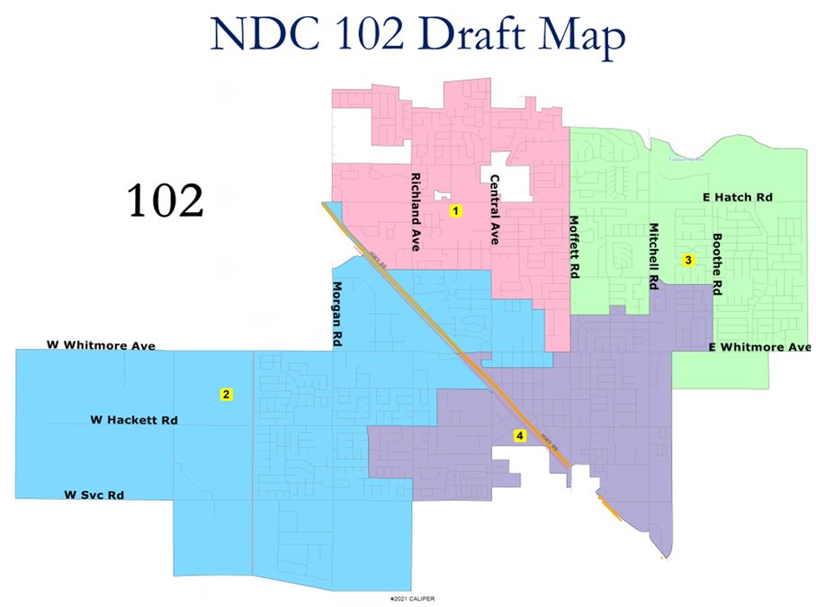
Yoakam said that with Ceres’s new population of 49,464 means each district must be drawn so that each district is about 12,366 residents to be fairly equal in size. He explained that districts is deemed equal in size if they don’t vary more than 10 percent between the most populated and least populated districts. The districts as they were originally drawn vary less than 7.1 percent.
The current districts also “respect” protected classes of voters by not splitting them up or combining them in a way that takes away their opportunity to elect a candidate of their choice in a district, according to the Federal Voting Rights Act.
“Your districts are basically compliant as they are currently drawn with equal population standards,” Yoakam told the council.
He specifically looked at Latino population, saying the distribution of Latinos is more widespread than it was in 2015.
“It’s changed quite a bit. Your city has, number one, become more Latino, and are perhaps more of voting age.”
Yoakam presented two draft maps that featured slight changes with less total variation in population, from 7.1 percent down to 3.47 percent. He made a slight change to the top of District 2 and a slight change to District 1. District 3 only changes by reaching down to take in 33 residents south of Whitmore in the Whitmore Ranch Annexation.
The second draft calls for District 2 on the west side of Highway 99 to move slightly south. District 4 moves into a northwesterly direction into an area that has a Latino concentration. Districts 1 and 3 have straightened lines.
“These are not major changes to your current districts that I have put in these draft maps,” said Yoakam. “They don’t need to be made major changes so I kept it to a minimum.”
Another map had been submitted too late to be considered on Saturday. He said that submittal eliminated any of District 2 leaping across east across the freeway. Yoakam said he hadn’t had enough time to crunch the population numbers of the late map.
Councilwoman Linda Ryno noted that the council really shouldn’t make a decision until after the public deadline for posting of their map ideas.
Councilman Mike Kline said he was disappointed because he thought the meeting was going to be interactive computer mapping program to see if new configurations meet districting criteria.
Ceres resident Jasmine Kaur said she prefers the first map, saying “it keeps the Punjabi Sikh community of interest together.” Kaur noted that her community of interest falls between Districts 2 and 3.
John Osgood expressed the need for one council district remaining contiguous on the west side of the freeway. He said he will be submitting his own maps that do just that. He also charged that the maps “favor incumbency and that’s one thing that state law does not require us to do.”
Paula Redfern commented that the new late map comes closest to representing District 2.
Kline wants to see District 2 remain totally on the west side and not have District 4 reach over to grab portions of Ceres on the west side. Ryno agreed, adding, “I never believed in making a boundary because of an existing councilmember.” Her reference was to the fact that her District 2 – which mostly occupies the west side of Ceres – was carved to include her residence on the east side of the freeway.
“If we can’t get all of the west side in District 2,” said Ryno, “and if it turns out that this little cutout of (District) 4 has to be on the west side because of numbers, I still think the west side is getting the representation that they speak often about, that they feel all the councilmembers including the mayor are all on the east side and they feel left out.”
Yoakam said the council has the option of adopting any map as long as it’s posted online for at least seven days.
Vice Mayor Bret Silveira commented that he was prepared to motion to keep the districts the same but after hearing Ryno and Kline strongly advocate for a change regarding the west side, he would await judgment.